
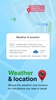
GPS Geotag Photos & Camera Map is designed to help you enhance your photography experience by automatically adding precise location data to your photos. Ideal for tracking when and where your photos are taken, this app integrates GPS coordinates, altitude, address, date, time, weather, and even a live map into your images. It serves as a practical solution for anyone who needs detailed geotagging, such as travelers, photographers, or professionals documenting specific locations.
Enhance Photos with Automatic Geotagging
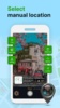
With GPS Geotag Photos & Camera Map, you can capture stunning images enriched with essential metadata without extra effort. The app instantly embeds GPS coordinates into your photos, along with customizable timestamps and location stamps. Additionally, it allows you to manually adjust latitude and longitude, ensuring complete control over your photo's geotagging details.
Customizable and User-Friendly Features
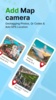
This app includes versatile customization options, enabling you to modify the font, size, position, and color of the location and timestamp details. Its GPS photomap stamping function is both fast and efficient, providing an intuitive experience for users. Moreover, the integrated live map and QR code scanner further enhance the app's utility, making it more than just a photography tool.
GPS Geotag Photos & Camera Map transforms how you document and organize your images, offering a seamless way to attach detailed location information. It ensures your photos always carry relevant context, providing value for both personal and professional use.
Requirements (Latest version)
- Android 7.0 or higher required
Comments
There are no opinions about GPS Geotag Photos & Camera Map yet. Be the first! Comment